DATA PROCESSING
Capturing aerial data is only part of the story. Raw data collected during a drone survey needs to be processed through specialised software before it becomes a usable, meaningful product.
Data processing involves turning thousands of images or millions of laser points into geo-referenced outputs that can be analysed, shared, and acted on.
At Flying Fox Drone Solutions, we offer data processing as a flexible, optional service charged separately from data capture. This means clients who have their own processing workflows or in-house GIS capability can simply receive their raw data and take it from there. For those who need finished outputs, we can take the data all the way through to final deliverables.
Key deliverables
We’ll work with you to identify which outputs best suit your project goals and deliver them in formats compatible with the GIS platforms and workflows your team already uses.
ONLINE VIEWER
For photogrammetry, we can provide a secure and private link to an online viewing platform.
This includes powerful tools to view, measure, annotate and produce your own downloadable maps.
GIS
We can provide various outputs suited to GIS software including:
.LAS, .SHP files
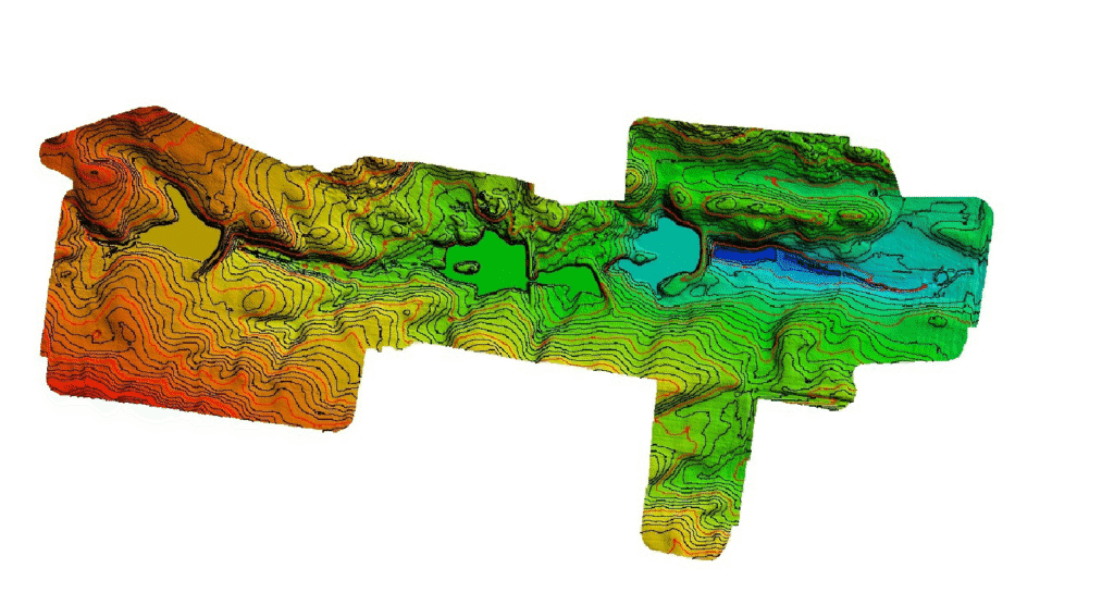
Digital Elevetaion Models
Point clouds
Cleaned LiDAR
Contours
processing only
If you have collected your own data, we can process this for you!
We are also able to assist with cartography.
DATA VISUALISATION
Orthomosaics
Digital Terrain Model
Digital Surface Model
Contours
Area/volume measurements

why choose us?
Our background in ecology means we understand the environments we work in and the decisions our data needs to support. We bring that knowledge into every project, alongside a genuine commitment to ethical operations, transparent communication, and culturally respectful practice. We take data sovereignty and Indigenous engagement seriously and work collaboratively with clients to make sure outputs are fit for purpose.
We hold all the necessary CASA licenses to operate legally and safely. This includes a Remote Operator’s Certificate (ReOC), Remote Pilot’s License (RePL) and Aeronautical Radio Operator’s Certificate (AROC). We also carry $20 million public liability insurance covering full flight and ground risks.
As a small business, we pride ourselves on being approachable with a practical focus on delivering what you actually need.